
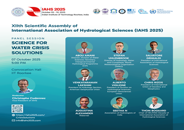
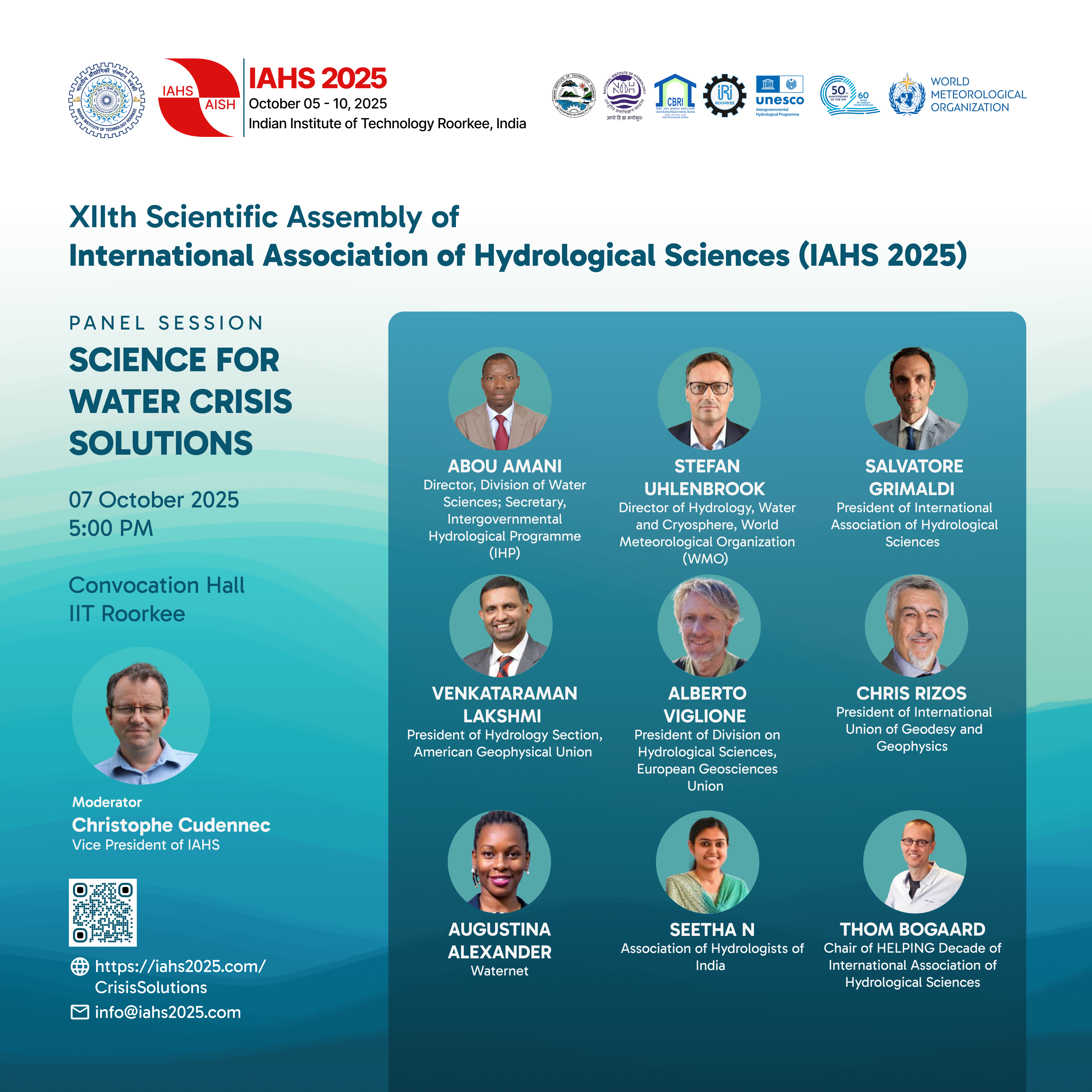
WMO HydroHub - MOXXI Working Group IAHS co-organized Innovation Workshop
Event
Side Event
WMO HydroHub - MOXXI Working Group IAHS co-organized Innovation Workshop on the sidelines of the IAHS Scientific Assembly 2025 11 October 2025, Roorkee, India
Saturday, October 11, 2025
Background
Managing water resources today is increasingly difficult due to the combined effects of global warming, demographic growth, greater human footprint, and escalating pollution (Manfreda et al, 2024, HSJ). Globally, the average annual losses due to riverine flooding are $388.4 billion, including $74.1 billion in infrastructure damages (GAR 2025 UNDRR p100). In mountain areas, changes in rainfall dynamics increased number of landslides, which have translated into approximately $34.2 billion in annual economic damage over 2000–2023 (GAR 2025 UNDRR p137).
Hydrological models remain fundamentally bound to the quality and quantity of underlying observations. Traditional gauge networks are costly to install and maintain, and they often generate datasets that are fragmented in space and time, constraining our understanding of key hydrological processes and its full cycle (Tauro et al., 2018; Sergeant & Nagorski, 2015; Manfreda, 2024). According to the WMO’s State of Climate Services: Water 2021, 60% of WMO Member States report a decline in their capabilities for hydrological monitoring. This hampers the ability of countries to provide hydrological data needed to deliver information and services for effectively planning and mitigating the impacts of climate change.
Most experts agreed (Blume et al, 2017) that bolstering network maintenance and deploying new sensors are the most pressing challenges for advancing hydrological science. This has been highlighted by the community and included as one of the Twenty-three unsolved problems in hydrology (“16. How can we use innovative technologies to measure surface and subsurface properties, states and fluxes at a range of spatial and temporal scales?) (Blöschl et al., 2019).
The challenges of hydrometry are amplified in difficult mountainous terrain like the Himalayas, which is a source of water for a large population in Asia and is characterized by steep peaks and rugged terrain. The rivers emerging in the Himalayan region are subject to flash floods in the upper reaches and carry high sediment loads during the peak rainy season. These factors make manual water gauging difficult, time-consuming, and life-threatening. For any increase in the number of monitoring nodes in a mountain hydrological network, cost is an important factor, particularly in low and middle-income countries like India, Nepal, and Bhutan. Many high-altitude rivers are also transboundary, requiring monitoring on both sides of the border to improve international cooperation in river management. Given the data scarcity in many high-altitude regions, there is a need for low-cost and robust solutions for river monitoring for several water resource management issues including early warning systems, irrigation and hydropower production in the region, among others.
The World Meteorological Organization (WMO) has been supporting hydrological services globally in the area of data collection and management. The support for hydrometry, defined as “Science of the measurement and analysis of the water cycle including methods, techniques and instrumentation used in hydrology” (International Glossary of Hydrology WMO-No. 385, 2012), is crucial for many other areas of operational hydrology and research. Since 2016, the WMO Global Hydrometry Support Facility (known as the WMO HydroHub) has been supporting National Meteorological and Hydrological Services (NMHSs) in their hydrological monitoring around it three focus areas: Increasing Capacity, Operationalizing Innovation and Optimizing Engagement. The overall mission of the project is to help expand a reliable and sustainable base of hydrometric data and information services in support of informed decision and policymaking in water management. Particularly, through the ”Operationalizing Innovation” component, the WMO HydroHub facilitates the uptake by NMHSs of new water monitoring approaches, from devices to management, including data transmission systems.
Innovation Workshops are convened to bridge the persistent gap between the proliferation of novel observational technologies, developed in academia, industry, and through citizen science, and their limited uptake in operational hydrological monitoring networks. By bringing together researchers, private-sector innovators, and end-users, these workshops help to (1) better understand the specific requirements and needs of operational contexts, (2) identify ideas and potential solutions, and (3) build partnerships with the aim of improving technologies, methods, manuals and documentation for existing and future hydrological monitoring solutions.
Within IAHS, the MOXXI Working group share complementary objectives that may help to enhance the WMO HydroHub plans reinforcing the collaboration between the academic community and the world of applied hydrologists. In particular, the Measurements and Observations in the XXI Century (MOXXI) was launched in 2013 as an IAHS Working Group emerging and growing during the IAHS decades, Prediction in Ungauged Basins (2003-2013) and the Panta Rhei (2013-2023). MOXXI’s mandate is to pinpoint critical gaps in our hydrological observing systems and drive the uptake of cutting-edge measurement techniques, from in-situ sensor networks to proximal and satellite remote sensing (Tauro et al., 2018). By convening hydrologists, technologists, and data scientists, a MOXXI Innovation Workshop directly serves to accelerate the co-design, field-validation, and operational integration of novel observation tools, charting clear pathways to embed experimental methods into routine water-monitoring practice.
The WMO HydroHub and MOXXI are partnering to host their third Joint Innovation Workshop, advancing collaboration and cutting-edge solutions in hydrometry.
Objectives
The WMO HydroHub – IAHS MOXXI WG co-organized Innovation Workshop will have the following objectives:
- Convene key stakeholders – NMHS representatives from the region, equipment manufacturers, researchers, and implementers – to foster regional mechanisms and collaboration for innovation activities.
- Showcase and facilitate hands-on learning of cutting-edge innovations in hydrometry, hydrological modeling, and water resource management, through interactive demonstrations and discussions, and showcase link to applications (e.g., HydroSOS).
- Identify adoption challenges, successes & pathways for scalable solutions in the Himalayan context.
Target Participants
- NMHSs (operational technical staff and mid-management): Central Water Commission (CWC) (India), Department of Hydrology and Meteorology (DHM), (Nepal), National Center for Hydrology and Meteorology (NCHM) (Bhutan)
- Basin Organizations
- Award winners of previous HydroHub Innovation Calls
- Innovation incubators active in the region
- ICIMOD, Research and Academia
- Private sector (e.g., through HMEI), start-ups)
- Communities & Local citizen science groups
- International Organizations & NGOs
- Foundations & Development agencies
Expected Outcomes
- Enhanced understanding of innovative hydrometric technologies & data solutions.
- Stakeholder alignment on key challenges & opportunities.
- Roadmap for the implementation of collaborative innovation pilots in the region.
- Capacity-building initiatives.
Immediate Outcomes
Downstream benefits
Workshop overview
| Time | Agenda | Speaker |
|---|---|---|
| 09:00 - 10:30 AM | Opening Session + Keynotes Moderator: Rokhaya Ba (WMO) |
|
| 09:00 – 09:10 AM | Welcome Remarks | Harry Dixon, Chair (WMO HydroHub) Salvatore Manfreda, Chair MOXXI Sumit Sen, Co-Chair IIT Roorkee |
| 09:10 – 09:20 AM | Introduction to MOXXI | Salvatore Manfreda, Chair MOXXI |
| 09:20 – 09:30 AM | Introduction to WMO HydroHub and Innovation Workshop | Rokhaya Ba, WMO Secretariat |
| 09:30 – 10:15 AM | Challenges in Himalayan Hydrology & Monitoring: NMHS perspectives (15’ per country, including Q&A) |
Dr. Sazzah Hossain, Bangladesh (online) India (CWC) |
| 10:15 – 10:30 AM | Challenges in transitioning innovations into operational use | Mark Randall (Australia) Or (WMO HydroHub Think Tank member) (online) |
| 10:30 - 10:45 AM | Tea break | |
| 10:45 – 11:45 AM | PICO talks, Innovation briefs Moderator: Sumit Sen (IIT Roorkee) |
|
| 10:45 – 11:00 AM | Advances during and beyond the 1st WMO HydroHub Innovation Call implemented in Bhutan | Andrew D. Wickert, President and Partner, Northern Widget LLC (Winner of WMO HydroHub 1st Innovation Call) (online) |
| 11:00 – 11:15 AM | Local solution to local needs | Selva Balan, Scientist, Hydraulic Instrumentation Division, CWPRS, Pune |
| 11:15 – 11:30 AM | Regional Initiative for Hydrological Monitoring of Andean Ecosystems (iMHEA) and non-contact stage monitoring | Wouter Buytaert, Professor in Hydrology and Water Resources, Imperial College London |
| 11:30 – 11:45 AM | International Data Centers: The Global Terrestrial Network – Hydrology (GTN-H) | Tunde Olarinoye, Hydrogeologist Researcher, International Centre for Water Resources and Global Change (UNESCO) |
| 11:45 – 12:00 PM | Break | |
| 12:00 – 01:00 PM | Panel discussion - Overcoming Barriers to Adoption & Scaling Innovations Moderator: Salvatore Manfreda (MOXXI) Panelists:
|
|
| 01:00 – 02:00 PM | Lunch | |
| 02:00 – 02:30 PM | Meet-up at the experimental flume (Hydraulics Lab) | |
| 02:30 – 05:00 PM | Hands-on of innovative technologies: Image velocimetry, Non-contact stage monitoring
|
|
| 05:00 PM | Refreshments | |
References
- Blöschl, G., Bierkens, M. F. P., Chambel, A., Cudennec, C., Destouni, G., Fiori, A., … Zhang, Y. (2019). Twenty-three unsolved problems in hydrology (UPH) – a community perspective. Hydrological Sciences Journal, 64(10), 1141–1158. https://doi.org/10.1080/02626667.2019.1620507
- Blume, T., van Meerveld, I., and Weiler, M., (2017). The role of experimental work in hydrological sciences – insights from a community survey. Hydrological Sciences Journal, 62 (3), 334–337. https://doi.org/10.1080/02626667.2016.1230675
- Dixon, H., Sandström, S., Cudennec, C., Lins, H. F., Abrate, T., Bérod, D., … Teichert, F. (2020). Intergovernmental cooperation for hydrometry – what, why and how? Hydrological Sciences Journal, 67(16), 2552–2566 https://doi.org/10.1080/02626667.2020.1764569
- Manfreda, S. (2025), The Space-Time Representation of Extraordinary Rainfall Events, Ecohydrology, 18:e2742. https://doi.org/10.1002/eco.2742
- Manfreda, S., Miglino, D., Saddi, K. C., Jomaa, S., Eltner, A., Perks, M., … Rode, M. (2024). Advancing river monitoring using image-based techniques: challenges and opportunities. Hydrological Sciences Journal, 69(6), 657–677 https://doi.org/10.1080/02626667.2024.2333846
- Sergeant, C.J. and Nagorski, S. (2015). The implications of monitoring frequency for describing riverine water quality regimes. River Research and Applications, 31(5), 602–610. https://doi.org/10.1002/rra.2767.
- Tauro, F., Selker, J., van de Giesen, N., Abrate, T., Uijlenhoet, R., Porfiri, M., … Grimaldi, S. (2018). Measurements and Observations in the XXI century (MOXXI): innovation and multi-disciplinarity to sense the hydrological cycle. Hydrological Sciences Journal, 63(2), 169–196. https://doi.org/10.1080/02626667.2017.1420191
- United Nations Office for Disaster Risk Reduction (2025). Global Assessment Report on Disaster Risk Reduction 2025: Resilience Pays: Financing and Investing for our Future. Geneva.
Maximum Number of Participants: 30


